HURRICANE MARIA INTENSIFIES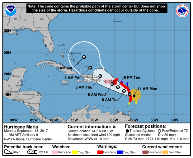 At 11 am, the centre of Hurricane Maria, now category 3, was near 14.7°N 60.1°W or about 130 miles (209 km) to the north -northeast of Saint Vincent and the Grenadines; moving west-northwest near 10 mph (17 km/h) and this motion with a decrease in forward speed is expected through Tuesday night. Maximum sustained winds have increased to near 120mph (193km/h) with higher gusts. Minimum central pressure was 967mb or 28.32inches. Hurricane-force winds extend outward up to 15 miles (30 km) from the centre, and tropical-storm-force winds extend outward up to 125 miles (205 km). For such, occasional gusty winds with very rough seas and feeder bands are of greatest concern to Saint Vincent and the Grenadines. Occasional strong westerly to south- westerly winds 20 – 30 mph (32 - 50km/h) with higher gusts is forecast for today, especially for the northern portions of the islands. Pockets of moderate to heavy showers, periods of rain, thunderstorms and gusty winds are already happening across SVG and forecast to continue on Tuesday and Wednesday. Rainfall accumulations of 4 - 8 inches (100 - 200 mm) from today through Wednesday are possible, with higher amounts in mountainous areas. Seas across SVG are now expected to be at least 4- 6 metres (13ft-20ft), especially on northern coasts of mainland, with life-threatening surf and rip current conditions. Maria is intensifying rather quickly and as it moves away from Saint Vincent and the Grenadines, northerly swells are expected across St. Vincent and the Grenadines on Tuesday and Wednesday. A Flood Warning is in effect until 6:00 pm today, Monday 18th, 2017 The High Surf Advisory and Small Craft Warning remain in effect. Sea bathers and other users of the sea should stay out of the water. Persons near rivers, streams and coastline areas prone to flooding and land slippage, should take precautions. The Saint Vincent Meteorological Services continue to monitor Hurricane MARIA; next update at 2:00pm today. 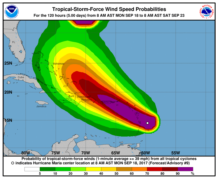 According to CNN, Hurricane Maria is forecast to rapidly strengthen over the next two days as it takes aim at Caribbean islands devastated by Hurricane Irma just days ago. Maria is one of three storms churning in the Atlantic Ocean, but it poses the most danger to the hurricane-battered Caribbean. Maria has prompted a hurricane warning for Martinique, Guadeloupe, Dominica, St. Kitts, Nevis and Montserrat. A tropical storm warning is in effect for Antigua and Barbuda, Saba, St. Eustatius and St. Lucia. A warning is typically issued 36 hours before the anticipated first occurrence of tropical-storm-force winds. The warning means that tropical storm conditions are expected within 36 hours. 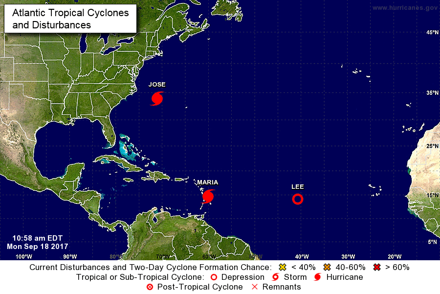 Meanwhile, the hurricane center said that Hurricane Jose is maintaining its intensity as it churns north, threatening "dangerous surf and rip currents" along the US East Coast in the next few days. Late Sunday, the Category 1 hurricane was about 305 miles (490 kilometers) southeast of Cape Hatteras, North Carolina, and moving north at 9 mph. While the center of Jose is expected to stay off from the US East Coast, the NHC said "swells generated by Jose are affecting Bermuda, the Bahamas, and much of the US east coast". The hurricane center said that Jose would produce heavy rain as it passes near southern New England and the mid-Atlantic on Tuesday and Wednesday, but that based on current forecasting the risk of flooding would be "limited in scope."
|
JSR CommunicationsWe offer the best, yet most affordable business; Individual support and publishing services. Archives
August 2021
Categories
All


|
||
 RSS Feed
