|
At 5:00 pm, Tropical Storm Kirk was near latitude 14.2 North, longitude 60.2 West. Maximum sustained winds were near 50 mph (85 km/h) with higher gusts. Although gradual weakening is anticipated during the next couple of days, little change in strength is expected before Kirk moves through the Lesser Antilles overnight. ‘T.S.Kirk’ is moving toward the west-northwest near 14 mph (22 km/h) and a west-north westward to westward motion is expected over the next couple days. The centre of the system is expected to pass to the north of mainland St. Vincent overnight, positioning to our north-west by early morning. 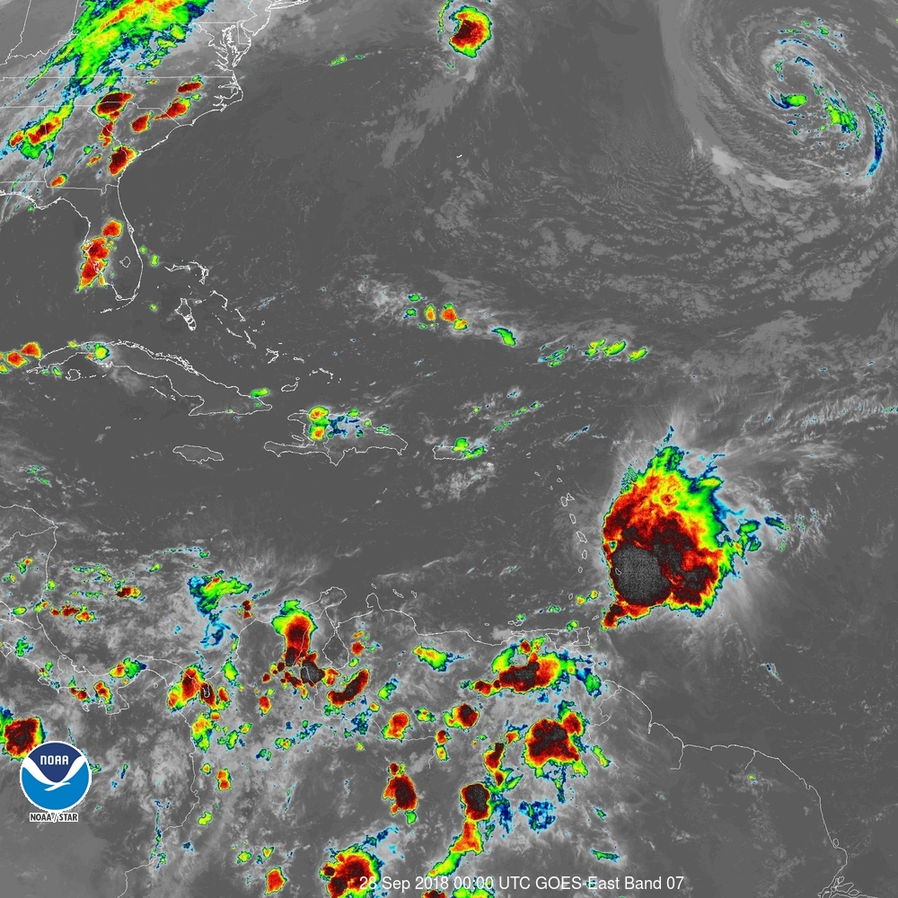 Tropical Storm Kirk at 8PM local time Light northerly breeze across SVG should increase by early morning, to 25 to 35 mph (40 to 55 km/h) with occasional gusts. Residents across SVG, should bear in mind that heavy rainfall and winds are occurring over the eastern portion of Kirk’s circulation. These winds and rains are likely to spread across SVG and other islands and possibly intensify by early morning. Light to moderate rain should increase to heavy showers with thunderstorms by early morning. Models indicate 1 to 3 inches (25 to 75 millimeters) rainfall accumulations are possible, but higher amounts are very likely across parts of SVG especially in mountainous areas. Persons in areas prone to flooding and landslides, near rivers streams and low lying areas should be alert. Large easterly swells up to 3.0 (10 ft) are expected to continue overnight into Friday. By late Friday, northerly swells generated by Post-Tropical cyclone Leslie, are expected to propagate southwards across our area. The north-eastern and eastern coasts could be affected first, then these northerly swells should be across SVG by late Saturday afternoon. These large waves and dangerous rip-tides can create unsafe conditions for small-craft operators, and these conditions may become even more adverse at times of high tide. Sea-bathers and other users of the sea are being warned to stay out of the water. A High-Surf Advisory and Small-Craft Warning remain in effect until 6:00 am Monday, 1st October. High Tide times are expected around: 8:49 pm tonight; 8:09 am and 9:44 pm on Friday; 8:51 am and 10:29 pm on Saturday; 9:35 am and 11:08 pm on Sunday 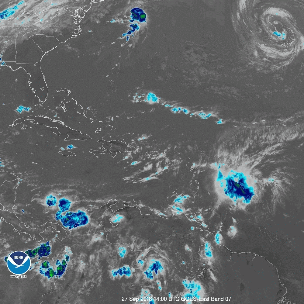 SUMMARY OF WATCHES AND WARNINGS IN EFFECT: A Tropical Storm Warning is in effect for... * Barbados * St. Lucia * Dominica * Martinique * Guadeloupe A Tropical Storm Watch is in effect for... * St. Vincent and the Grenadines Interests elsewhere in the central and northern Lesser Antilles should monitor the progress of Kirk. For storm information specific to your area, please monitor products issued by your national meteorological service. 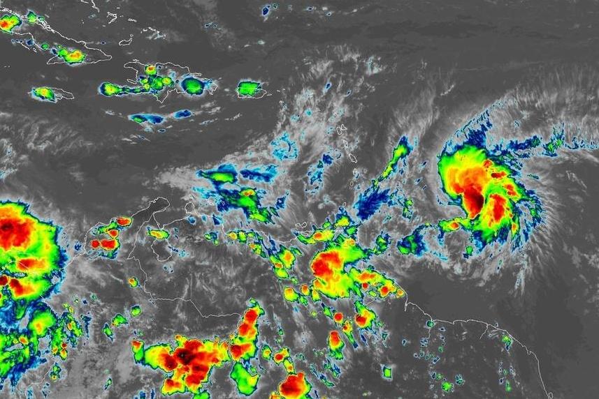 A Tropical Storm watch remains in effect for St.Vincent and the Grenadines.
At 5:00 pm, Tropical Storm Kirk was near 12.7N 55.7W or about 365 miles …587 km east of St. Vincent and the Grenadines. All Schools will be closed tomorrow Thursday 27th September 2018 due to the impending passage of Tropical Storm Kirk. Acting Prime Minister Montgomery Daniel says an assessment will be done by NEMO regarding public servants attending work. Maximum sustained winds have increased to near 60 mph…95km/h with tropical-storm-force winds extending outwards to about 115 miles (185 km) to the northeast, and 90 miles (145 km) to the southeast of the center. Movement was towards the west northwest near 18 mph (30 km/h), and this motion is expected to continue over the next few days. The center of ‘Kirk’ is expected to pass between 80 to 100 miles north of St. Vincent and the Grenadines between Thursday morning and Thursday afternoon. Sustained winds of between 25 to 35 mph (40 to 55 km/h) with higher gusts are possible across the islands tomorrow as the system passes to the north. In addition, pockets of moderate to heavy showers, periods of rain and scattered thunderstorms can be expected with rainfall accumulations of 2 to 4 inches (50 to 100 millimeters) and isolated higher amount in mountainous areas. Residents and motorists in areas prone to flooding and landslides, near rivers and streams are advised to be alert. Large easterly swells of 3.0 to 4.5 (10 to 15 ft) are forecast to accompany the system. By weekend, northerly swells generated by Post-Tropical cyclone Leslie, are expected to propagate southwards across our area. Large waves and dangerous rip-tides can create unsafe conditions for small-craft operators, and these conditions may become even more adverse at times of high tide. Sea-bathers and other users of the sea are advised to stay out of the water. A High-Surf Advisory and Small-Craft Warning is now in effect until 6:00 am Monday, 1st October. High Tide times are expected around: 7:28 am and 8:49 pm on Thursday; 8:09 am and 9:44 pm on Friday, 8:51 am and 10:29 pm Saturday and 9:35 am and 11:08 pm on Sunday. The St. Vincent and the Grenadines Meteorological Services continues to monitor the progress of Tropical Storm Isaac, presently located East of the Lesser Antilles. 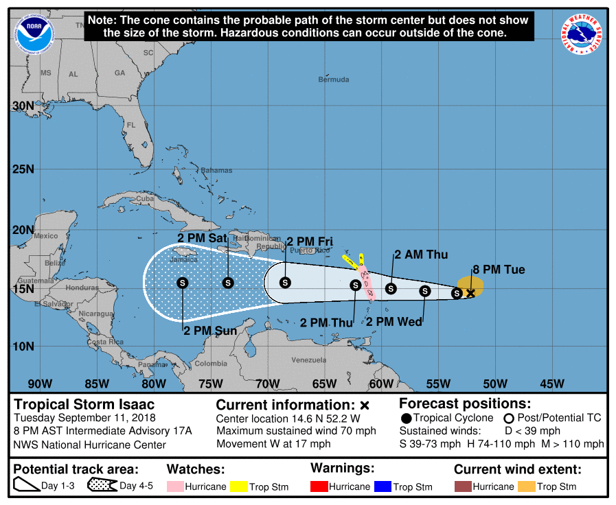 At 5 pm Tropical Storm Isaac was centered near latitude 14.6° North; longitude 51.3° West or about 670 miles (1075 km) east northeast of Saint Vincent and the Grenadines. Maximum sustained winds remain near 70 mph or 110 km/h with higher gusts. Tropical-storm-force winds extend outward 105 miles (165) km from the center. “Isaac” continues to move westward at 17 mph (28 km/h). On the current forecast track, the center of this system is forecast to pass near Dominica, or approximately 150 miles (240 km) north of mainland St. Vincent by early Thursday. However, by early tomorrow, an outer band associated with “Isaac” could result in some showers and possible isolated thunderstorm across our islands. As the system progresses westward, an increase in moderate to heavy showers and occasional gusty winds can be expected from Thursday and into Friday. Forecast Models suggest that rainfall accumulations of 50 to 75 mm (2 to 3 inches) are possible during the passage of “Isaac”. Sea conditions are also forecast to deteriorate from late Wednesday with swells peaking near 3.5 meters or 11 feet. A small-craft warning will be in effect from 6 pm, Wednesday 12th September, 2018. The St Vincent and the Grenadines Meteorological Services will continue to monitor this system and provide the necessary updates and/or advisories. Prepared by: Billy Jeffers (Mr.) Aviation Services Department Argyle Ministry of National Security, Air and Sea Port Development Phone: 784-4584477 Fax: 784-4580868 Email: [email protected] Website: www.meteo.gov.vc  Do you ever experience any of these health issues?
If so, these are just some of the signs that you may have a fungal infection known as candida. In this article you will learn other candida symptoms along with what causes candida and the diet to naturally treat candida. Like this post and share it below 👇 |
JSR CommunicationsWe offer the best, yet most affordable business; Individual support and publishing services. Archives
August 2021
Categories
All


|
 RSS Feed
