HURRICANE MARIA INTENSIFIES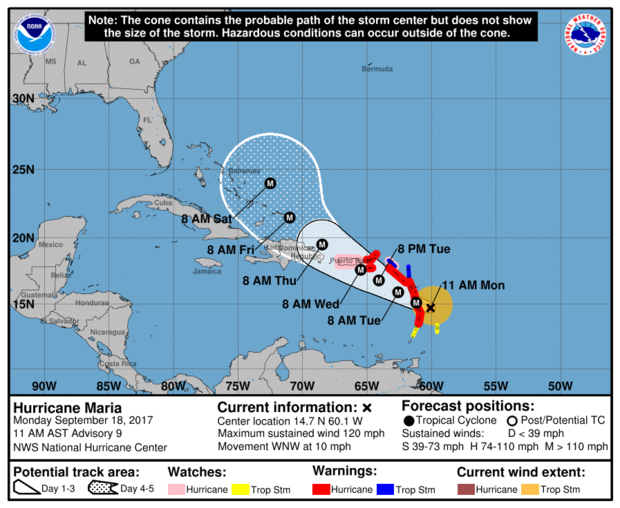 At 11 am, the centre of Hurricane Maria, now category 3, was near 14.7°N 60.1°W or about 130 miles (209 km) to the north -northeast of Saint Vincent and the Grenadines; moving west-northwest near 10 mph (17 km/h) and this motion with a decrease in forward speed is expected through Tuesday night. Maximum sustained winds have increased to near 120mph (193km/h) with higher gusts. Minimum central pressure was 967mb or 28.32inches. Hurricane-force winds extend outward up to 15 miles (30 km) from the centre, and tropical-storm-force winds extend outward up to 125 miles (205 km). For such, occasional gusty winds with very rough seas and feeder bands are of greatest concern to Saint Vincent and the Grenadines. Occasional strong westerly to south- westerly winds 20 – 30 mph (32 - 50km/h) with higher gusts is forecast for today, especially for the northern portions of the islands. Pockets of moderate to heavy showers, periods of rain, thunderstorms and gusty winds are already happening across SVG and forecast to continue on Tuesday and Wednesday. Rainfall accumulations of 4 - 8 inches (100 - 200 mm) from today through Wednesday are possible, with higher amounts in mountainous areas. Seas across SVG are now expected to be at least 4- 6 metres (13ft-20ft), especially on northern coasts of mainland, with life-threatening surf and rip current conditions. Maria is intensifying rather quickly and as it moves away from Saint Vincent and the Grenadines, northerly swells are expected across St. Vincent and the Grenadines on Tuesday and Wednesday. A Flood Warning is in effect until 6:00 pm today, Monday 18th, 2017 The High Surf Advisory and Small Craft Warning remain in effect. Sea bathers and other users of the sea should stay out of the water. Persons near rivers, streams and coastline areas prone to flooding and land slippage, should take precautions. The Saint Vincent Meteorological Services continue to monitor Hurricane MARIA; next update at 2:00pm today. 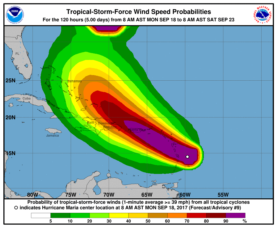 According to CNN, Hurricane Maria is forecast to rapidly strengthen over the next two days as it takes aim at Caribbean islands devastated by Hurricane Irma just days ago. Maria is one of three storms churning in the Atlantic Ocean, but it poses the most danger to the hurricane-battered Caribbean. Maria has prompted a hurricane warning for Martinique, Guadeloupe, Dominica, St. Kitts, Nevis and Montserrat. A tropical storm warning is in effect for Antigua and Barbuda, Saba, St. Eustatius and St. Lucia. A warning is typically issued 36 hours before the anticipated first occurrence of tropical-storm-force winds. The warning means that tropical storm conditions are expected within 36 hours. 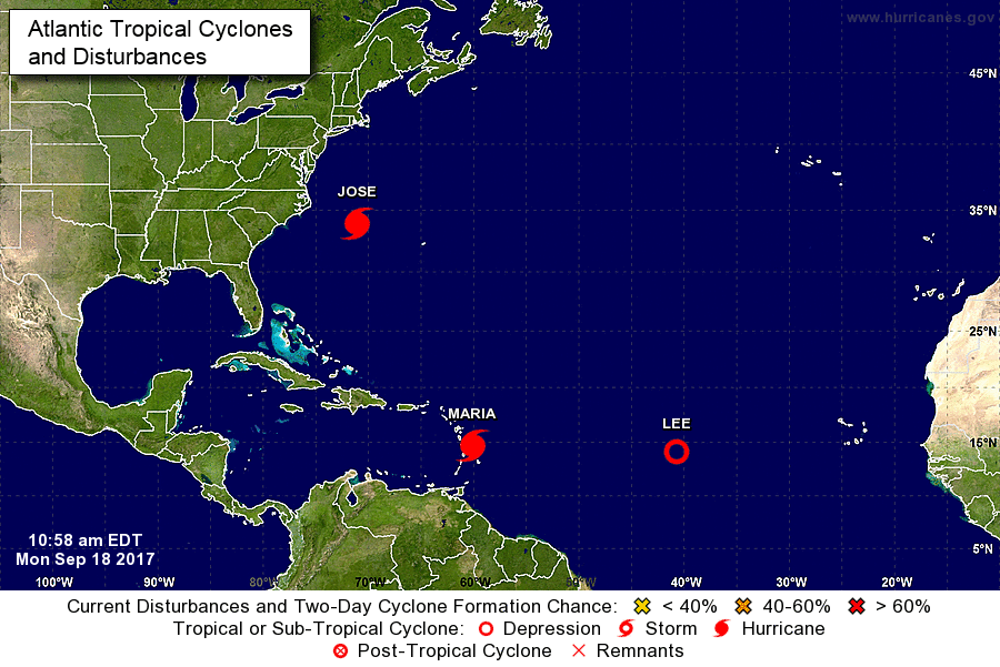 Meanwhile, the hurricane center said that Hurricane Jose is maintaining its intensity as it churns north, threatening "dangerous surf and rip currents" along the US East Coast in the next few days. Late Sunday, the Category 1 hurricane was about 305 miles (490 kilometers) southeast of Cape Hatteras, North Carolina, and moving north at 9 mph. While the center of Jose is expected to stay off from the US East Coast, the NHC said "swells generated by Jose are affecting Bermuda, the Bahamas, and much of the US east coast". The hurricane center said that Jose would produce heavy rain as it passes near southern New England and the mid-Atlantic on Tuesday and Wednesday, but that based on current forecasting the risk of flooding would be "limited in scope."
TROPICAL STORM CONDITIONS ARE LIKELY TO AFFECT SVG…. GENERALLY IN THE NEXT 48 HOURS as MARIA nears hurricane intensity. 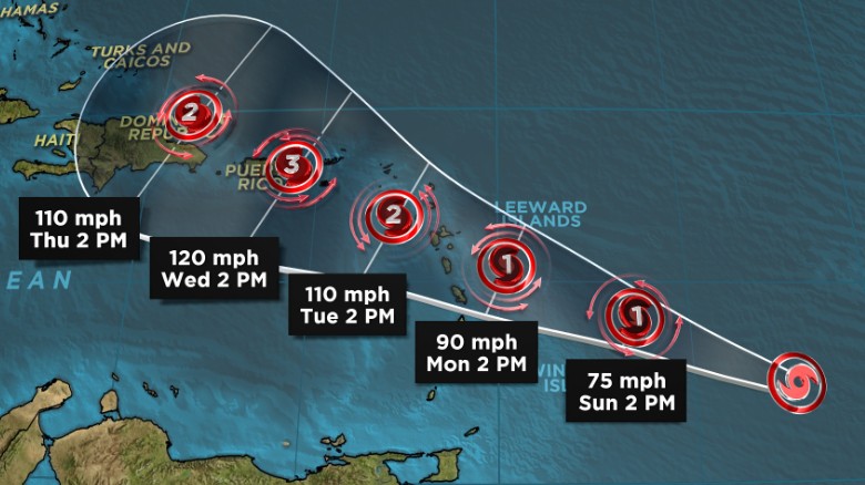 Tropical Storm Maria forms in the Atlantic. At 5 am, the centre of Tropical Storm Maria was located 13.0°N 54.9°or about 365 miles (590 km) to the east of Saint Vincent and the Grenadines moving westward-northwestward near 15 mph (24 km/h), and this motion with a further reduction in forward speed is expected over the next couple of days. The center is expected to pass approximately 145 miles northeast, then north of St Vincent and the Grenadines Monday afternoon nearing Category 2 on the Saffir Simpson scale. Maximum sustained winds have increased to near 65 mph (100 km/h) with higher gusts and further strengthening is forecast. Minimum central pressure was 994 mb or 29.36 inches. 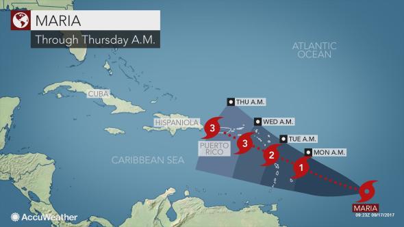 As storm force winds extend outward up to 60miles (95km) from the centre, instability could begin affecting SVG this evening with an increase in cloudiness, followed by pockets of moderate to heavy showers, periods of rain, thunderstorms and occasional gusty winds. Feeder bands are forecast to continue affecting the islands on Tuesday and Wednesday with rainfall accumulations up to 8 inches (200 mm) possible. This afternoon, light variable winds are expected to increase possibly reaching near gale force 30-38mph (47- 61km/h) by Monday afternoon. Strong westerly to southwesterly winds on Tuesday, decrease by Wednesday as Maria moves away from Saint Vincent and the Grenadines. Sea swells are expected to rise this afternoon peaking at 4 – 6 meters (13ft -20 ft) by Monday, with life-threatening surf and rip current conditions. Sea bathers and other users of the sea are advised to stay out of the water during the passage of Maria. A high- surf advisory and small craft warning remain in effect until 12noon Tuesday. All are urged to be vigilant; persons near rivers, streams and coastline areas prone to flooding and land slippage, should take precautions. BE PREPARED! The Saint Vincent Meteorological Services continue to monitor; the next update will be at 8:00 am today. 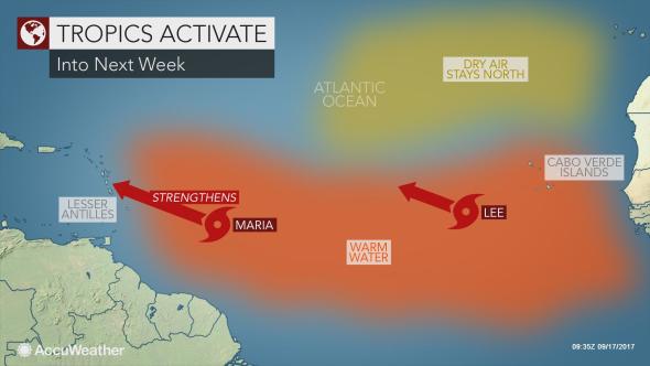 Meanwhile, Tropical Depression 14 strengthened into Tropical Storm Lee in the eastern Atlantic Ocean on Saturday. AccuWeather Senior Meteorologist Dan Pydynowski said, “Lee will not threaten any land for at least the next five days as it works its way northwestward across the open waters of the eastern and central Atlantic”. In fact, Pydynowski expects Lee to dissipate by the middle to latter part of next week. ProjectMEN2020 a non for profit voluntary organization, which seeks to help the male man through spiritual, social and educational insights hosted a media conference on Wednesday 13th September 2017, at the Frenches House Conference Hall, Kingstown, from 10 am. The media conference addressed the failure of men in the family and society and how it contributes to the recent spate of crimes and violence and the annual high incidence of crimes over recent years in SVG and informed the media on it's plans to celebrate International Men’s Day in SVG on Sunday 19th November 2017. The organisation also informed of their plans to host their annual national Men’s Conference in March 2018, which has been taking place here since 2014.  Background:
ProjectMEN2020 challenges the male man to see their lives as God had originally intended for them to live, by His righteous standards, through spiritual insight. The project’s purpose is to reach, teach, equip and release men into Kingdom purpose, locally, nationally, regionally and globally. It is managed by a national Project Team which includes 7 rural coordinators and their teams. The project was launched on March 20th and 22nd of 2014, when it hosted a pastors and leaders seminar and a National Men’s Conference. That same year it hosted 7 rural conferences throughout SVG under the same theme: “Righteous Manhood 2014”. During March 19-21, 2015, it hosted a pastors, leaders and business men gathering and a National Men’s Conference under the theme: “Biblical Manhood 2015”. The Conference for 2016 was held on 24-26 March and the theme was “Kingdom Culture 2016”. In 2017 the theme was “Fatherhood 2017” and was held on April 6 and 8. Purpose: Our purpose is to create an environment that challenge men to:
Mission Statement: Our Mission is to provide a ministry/movement based on relationships rather than activity, that empowers men to be the spiritual leaders, husbands and fathers God had originally intended for them to be. Vision: Three point- To establish a True and Intimate relationship with Jesus Christ, through prayer, worship, and study of God's Word. To build strong Godly Character through, Integrity and Accountability with each other. To help men accept their spiritual role of leadership beginning at home, the church, the marketplace and the wider nation. 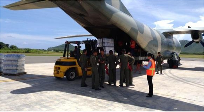 Venezuelan Military Aircraft loading supplies at the Hewanorra International Airport. (PRESS RELEASE) – Venezuela is among the countries coming to the aid of the Caribbean region following the devastating impact of Hurricane Irma, which destroyed infrastructure on islands, such as Barbuda. The government of Venezuela is the first responder to the crisis in the island of Barbuda, which was devastated by Hurricane Irma in the early hours of Wednesday morning, leaving over 90 percent of the housing stock uninhabitable. Venezuela contributed a cargo plane full of supplies, as well as medics and disaster relief workers, to the recovery effort on the island nation of Antigua and Barbuda. The aid sent included 34 civil defense specialists, 20 firefighters, along with 10 tons of supplies like water, mattresses, mats, boots, gloves, tents and medicine. Relief efforts, coordinated by Antigua and Barbuda’s National Office of Disaster Services along with the Red Cross, have started in earnest with multiple relief flights and vessels landing on Barbuda. In the aftermath of Hurricane Irma and with Hurricane Jose threatening to increase the tragedy, two Venezuelan military aircraft were available for the evacuation effort of Barbuda. Many persons were safely transported to Antigua, while Jose made its way in the region. The pilots had to maneuver in a complex scenario, with a damaged airstrip, and demonstrated a high level of skill and training in this emergency. Another military plane was dispatched to Saint Lucia, and collected the aid support, mainly large quantities of bottled water, which was sent to other islands. Venezuela’s Foreign Minister Jorge Arreaza reportedly said, “We are doing something beautiful, that is being able to help the brotherly peoples in the difficulties – this is the essence of the Bolivarian Revolution and of the Bolivarian Alliance for the Peoples of Our America (ALBA). Venezuela sends 10 tons of humanitarian aid to Saint Martin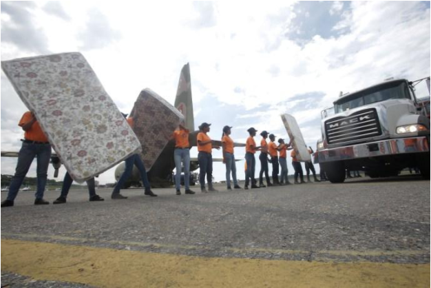 On Sunday, a new shipment carrying 10 tons of humanitarian aid left on board an aircraft of the Bolivarian National Armed Forces of Venezuela to Saint Martin, one of the 13 islands in the northern Caribbean area affected by Hurricane Irma, one of the most powerful storms that has hit the Atlantic and which has destroyed 95% of the infrastructure of this French Antilles. Mattresses, blankets, sheets, canned foods, medicines, first aid kits and clothing, made up this second shipment, responding to the requirements of the authorities of Saint Martin. From ramp 4 of the Maiquetía International Airport "Simón Bolívar", located in Vargas state, Néstor Reverol, Minister of Internal Affairs, Justice and Peace reported on the evacuation of 40 Venezuelans who were on the island of Saint Martin, who returned to the country aboard this aircraft. He continued by pointing out that the Bolivarian Government is making all coordination with the Antigua and Barbuda authorities to establish an air bridge with the aircrafts of the Bolivarian national Armed forces. In the same way, permanent communication is maintained with the authorities of Haiti and Cuba, to assist the peoples of these sister nations, affected by the passage of Irma. By Telesur  Issued by the Barbados Meteorological Services at 6:00 pm Thursday 7th September, 2017A Small Craft Warning and High Surf Advisory for St.Vincent and the Grenadines is in effect from 6:00 p.m today, Thursday 7th September, 2017 through to 12:00 p.m Saturday 9th September, 2017. A Small-Craft Warning means in this case that seas equal to or greater than 3m (10ft) will be affecting the marine area. A High-Surf Advisory is issued when breaking wave action poses or is expected to pose a threat to life and property within the surf zone. At 5:00 p.m, Hurricane “Jose” was centered near 15.5°N, 52.4°W or about 590 MI...955 KM east of the Lesser Antilles. Jose was moving towards the west- northwest at about 18 mph... 30 km/h with maximum sustained winds of 120 mph... 195 km/h. This makes Jose a Category 2 system on the Saffir-Simpson Wind Scale and further strengthening is forecast. Although “Jose” is not expected to directly impact St.Vincent and the Grenadines, it is forecast to generate above normal easterly to east-northeasterly swells of 3.0 to 4.0m (10 – 13 feet) mainly along eastern and northern coastlines of St. Vincent and the Grenadines starting early tomorrow. This activity is expected to persist into Saturday and may become even more adverse at times of high tide. Large waves and dangerous rip-currents can be expected mainly along eastern and northern coastlines of St. Vincent and the Grenadines; this will result in unsafe conditions for small-craft operators. Sea-bathers and other users of the sea are also advised to stay out of the water. As a consequence, a HIGH-SURF ADVISORY and SMALL-CRAFT WARNING is in effect for St. Vincent andthe Grenadines from 6:00 p.m today, Thursday 7th September through 12:00 noon Saturday 9th September, 2017. Prepared by Desiree Neverson- Jack
 Rough northerly sea swells will continue to peak near 3.5 meters (12 feet). Small craft operators and sea bathers are advised to stay away from the sea and beaches due to life threatening swells and extremely rough seas. Residents living near the coastlines are asked to be very vigilant. Isolated pockets of moderate to heavy showers and thunderstorms are also likely over SVG as the center of dangerous Category 5 Hurricane Irma continues to move across the Northern Leeward Islands. Residents and motorists in areas prone to flooding are advised to exercise caution.
|
JSR CommunicationsWe offer the best, yet most affordable business; Individual support and publishing services. Archives
August 2021
Categories
All


|
||||||
 RSS Feed
