|
TROPICAL STORM CONDITIONS ARE LIKELY TO AFFECT SVG…. GENERALLY IN THE NEXT 48 HOURS as MARIA nears hurricane intensity. 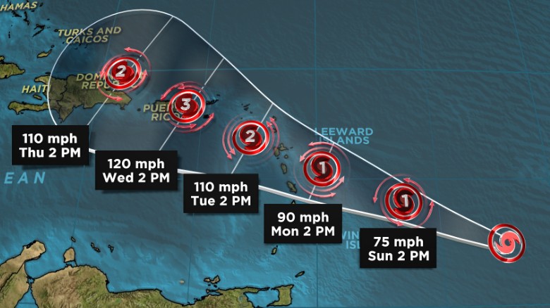 Tropical Storm Maria forms in the Atlantic. At 5 am, the centre of Tropical Storm Maria was located 13.0°N 54.9°or about 365 miles (590 km) to the east of Saint Vincent and the Grenadines moving westward-northwestward near 15 mph (24 km/h), and this motion with a further reduction in forward speed is expected over the next couple of days. The center is expected to pass approximately 145 miles northeast, then north of St Vincent and the Grenadines Monday afternoon nearing Category 2 on the Saffir Simpson scale. Maximum sustained winds have increased to near 65 mph (100 km/h) with higher gusts and further strengthening is forecast. Minimum central pressure was 994 mb or 29.36 inches. 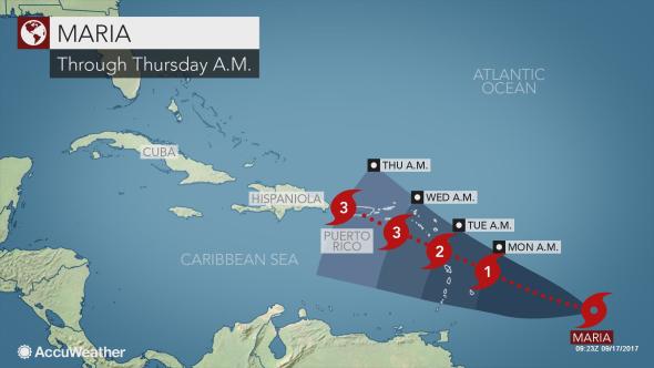 As storm force winds extend outward up to 60miles (95km) from the centre, instability could begin affecting SVG this evening with an increase in cloudiness, followed by pockets of moderate to heavy showers, periods of rain, thunderstorms and occasional gusty winds. Feeder bands are forecast to continue affecting the islands on Tuesday and Wednesday with rainfall accumulations up to 8 inches (200 mm) possible. This afternoon, light variable winds are expected to increase possibly reaching near gale force 30-38mph (47- 61km/h) by Monday afternoon. Strong westerly to southwesterly winds on Tuesday, decrease by Wednesday as Maria moves away from Saint Vincent and the Grenadines. Sea swells are expected to rise this afternoon peaking at 4 – 6 meters (13ft -20 ft) by Monday, with life-threatening surf and rip current conditions. Sea bathers and other users of the sea are advised to stay out of the water during the passage of Maria. A high- surf advisory and small craft warning remain in effect until 12noon Tuesday. All are urged to be vigilant; persons near rivers, streams and coastline areas prone to flooding and land slippage, should take precautions. BE PREPARED! The Saint Vincent Meteorological Services continue to monitor; the next update will be at 8:00 am today. 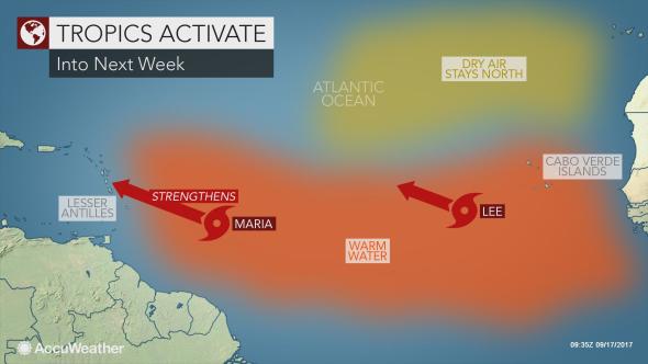 Meanwhile, Tropical Depression 14 strengthened into Tropical Storm Lee in the eastern Atlantic Ocean on Saturday. AccuWeather Senior Meteorologist Dan Pydynowski said, “Lee will not threaten any land for at least the next five days as it works its way northwestward across the open waters of the eastern and central Atlantic”. In fact, Pydynowski expects Lee to dissipate by the middle to latter part of next week. |
JSR CommunicationsWe offer the best, yet most affordable business; Individual support and publishing services. Archives
August 2021
Categories
All


|
 RSS Feed
